By Dustin Brown
From the works of art peering across the East River from Socrates Sculpture Park to the public beaches lining the Rockaways’ southern shore, the borough’s extensive waterfront is one of its most precious resources.
But fears that much of the land is not being used to its best potential have spawned legislation to force the city to take a hard look at its waterfront holdings and possibly find new uses for some sites.
Under a law signed by Mayor Michael Bloomberg last week, the city will be required to compile a semi-annual inventory of all municipally owned waterfront properties. The information will be available for easy public viewing.
“This is the first step in a process that will allow us to identify dormant or misused lots and potentially transform them into parks, housing or commercial property in a revitalization of our waterfront property,” Bloomberg said July 29 as he signed the bill into law.
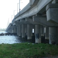
The measure has significant implications for Queens, which boasts nearly 30 percent of the city’s shoreline along two separate waterfronts. The East River lines the borough’s northern and western edges, while Jamaica Bay and the Atlantic lie along the south.
“This is the key to revitalizing the waterfront,” said Evan Thies, an aide to Councilman David Yassky (D-Brooklyn), who chairs the Select Committee on Waterfronts and introduced the legislation. “If we don’t know where these sites are, if that information isn’t readily available to the public, then they are a loss.”
Bill Woods, director of Waterfront and Open Space Planning for the Department of City Planning, estimates that between 65 percent and 70 percent of borough’s waterfront is owned by the city — including parks, the airports and utilities like sewage treatment plants.
Although an inventory of city-owned property is already conducted annually by the Department of City Planning, Woods said the new system would “put it in perhaps a more easily used format that’s convenient and just will focus on the waterfront.”
A few months ago, Yassky cited two waterfront sites in Queens on his list of the city’s “Top 10 Waterfront Wastes:” the Hallets Cove lot, a stretch of land between the Astoria Houses and Socrates Sculpture Park with “great views and an actual sand beach;” and the Flushing River, where “a city-owned plot lies idle, surrounded by a wall of corrugated steel.”
The land eyed along Hallets Cove consists of a warehouse controlled by the Department of Citywide Administrative Services and a rickety dock under the authority of the Department of Business Services, which together could link the public housing project with the city park.
“If we put all those pieces together, then Hallets Cove is a wonderful waterfront place rather than the critical mass of nothingness that it is right now,” said Carter Craft, the program director at the Metropolitan Waterfront Alliance.
Both sites could potentially be reclaimed as promenades linking existing green spaces and providing residents with additional waterfront access, Yassky explained.
“It is my hope that once the inventory bill reveals these properties to the public, it will spur a collective push to find better uses for our waterfront land,” Yassky said in a release last month after the City Council passed the bill.
A “Plan for the Queens Waterfront” issued by the Department of City Planning in 1993 called for the preservation of areas that contain significant natural resources — specifically along Jamaica Bay and the borough’s eastern north shore by Long Island Sound, much of which has already been designated as parkland.
Meanwhile, much of the western Queens waterfront originally dedicated to industry has fallen into disuse and evolved into redevelopment opportunity for residential and commercial uses, like the Queens West project currently rising in Hunters Point. The plan also calls for a nearly continuous esplanade to be carved along the East River through Astoria, Ravenswood and Hunters Point.
Woods said his department’s overarching goal has been to “identify opportunities and strategies for bringing the public to the waterfront and getting more public access, including increased water use, increased ferry stops and even boat launches.”
Reach reporter Dustin Brown by e-mail at Timesledger@aol.com or call 229-0300, Ext. 154.